Prescribed Burns
Examine the importance and impact of fire on the landscape

Prescribed burns, where professional foresters carefully plan and set fires in certain natural areas, are a common practice today. Forest managers use prescribed burn techniques to protect and restore natural habitat, to mimic natural processes, and to reduce forest fuel levels to help prevent wildfires. On November 21, 2014, the Florida Forest Service conducted a prescribed burn in Blackwater River State Forest. At the same time, NASA’s Landsat 8 satellite passed overhead and collected an image of the fire.
In this activity you will learn about the importance of fire in healthy forest ecosystems. As part of this, you will examine satellite imagery to observe and document the effects of, and recovery from, a prescribed burn that was conducted in Blackwater River State Forest.
The longleaf pine is a fire-resistant tree, which means it has low levels of sap and dead wood on the plant. Longleaf pine forests traditionally covered much of the Southeastern United States. For centuries, periodic fires helped to keep other trees, such as oaks, from encroaching in longleaf pine forests. These fires also removed other woody plants and shrubs from the area, increased the amount of light reaching the forest floor, and recycled nutrients into the soil. As a result, healthy longleaf pine ecosystems support an understory with a high diversity of grasses, including native wiregrass.
The open understory of longleaf pine forests provides an ideal habitat for species such as the gopher tortoise, an important ecosystem engineer and other keystone species. Gopher tortoises dig deep burrows to serve as their homes–the burrows can be up to 10 feet deep and may be up to 40 feet long. These burrows provide shelter during fires for other animals as well as the tortoises, and are used by burrowing owls, Eastern indigo snakes, gopher frogs, and other wildlife. In all, over 300 different animals and insects use the burrows for shelter. But when longleaf pine forests become too overgrown with other woody trees and shrubs, wiregrass gets shaded out, and the brush makes it difficult for tortoises to dig their burrows.

A gopher tortoise in its burrow, Image by Sean McCann CC-BY-NC-SA courtesy of EOL.
The endangered red-cockaded woodpecker also makes its home in the longleaf pine ecosystem. Mature stands of longleaf pines are susceptible to red heart disease, a fungus which softens their wood, making it easier for red-cockaded woodpeckers to dig holes into their trunks and create nest cavities to raise their young. Like the gopher tortoise, the red-cockaded woodpecker is a keystone species in the longleaf pine ecosystems; a keystone species is a species which helps to maintain an ecosystem’s structure, learn more here. Twenty-seven other species of animals have been documented using the cavities created by the woodpecker, some examples are Southern flying squirrels and great crested flycatchers.
Other species which prefer longleaf pine ecosystems include Bachman’s sparrow, the pine snake, and the brown-headed nuthatch. To learn more about these species and fire ecology in the Southeastern United States visit the US Fish and Wildlife page or the Encyclopedia of Life.
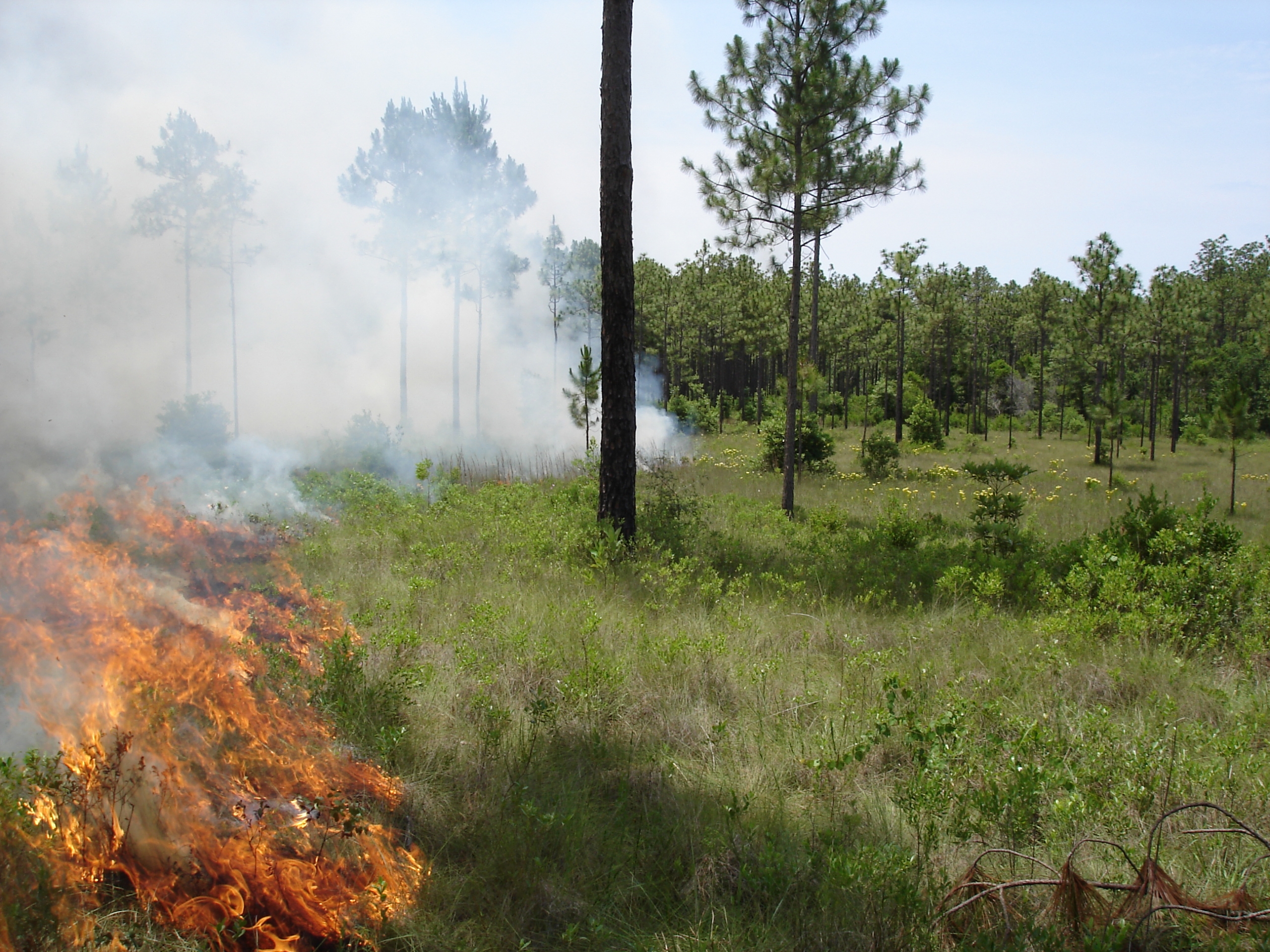
Photo Courtesy of the Jackson National Guard
Before the arrival of European settlers, Native Americans used fire as a means of land management to promote hunting and agriculture as well as clear trails and the areas around settlements.
After settlers arrived, they worked to suppress and restrict fire, a practice that persisted in forest management into the 1970’s. As a result of this fire suppression, the amount of plant material that built up in forests reached unnaturally high levels. In addition, the types of plants and animals in the forests slowly changed over time, as woody plants such as oaks were able to survive without frequent fires. As the frequency of fire decreased, the amount of available fuel, dead plant material and vegetation easily susceptible to burning increased. When eventually ignited by lightning or other fire triggers, the unnaturally high fuel load led to larger, more severe, and more difficult to control fires. The end result of these unprecedentedly severe fires was a longer forest recovery time, due in part to the larger amount of land affected and the greater amount of vegetation destruction.

Photo Courtesy of the Jackson National Guard
The U.S. government passed legislation in the late 1800’s that mandated the protection of national forest reserves – lands initially protected to provide timber for commercial logging, which is the practice of cutting down trees to be sold. The legislation mandated protecting these forests from fire to prevent commercial timber from burning. While this outlook helped preserve the scenic beauty of the land and protect timber, it disrupted the natural process of forests to replenish themselves sustainably (being maintained at a certain level). Without fire to remove dead plant material and small plants on the forest floor, forests fuel levels increased.
In the 1960’s forest managers began to view fire differently. New research showed that fire was beneficial to the management of national parks and national forests. The shift towards embracing fire as an essential natural event was first raised in a 1963 government report called the Leopold Report. The report advocated for the use of fire as “the most ‘natural’ and much the cheapest and easiest” way of controlling vegetation within parks.
By 1978, the US Forest Service had accepted the use of fire in forest management. Since the 1970’s, prescribed burns have become more prominent across the United States as a management tool for sustaining habitats. Both State and Federal agencies prescribe fires for a variety of reasons, such as reducing the amount of fuel around developed areas, maintaining natural landscapes, and maintaining historic landscapes such as battlefields. To see a timeline of United States fire history, visit this National Park Service site.
Unlike prescribed burns, wildfires are unplanned and are caused either by natural events, such as lightning strikes, or by human activity. These fires can provide ecological benefits in the same way that prescribed burns do, but also pose significant risks. In areas where there is an unnaturally high buildup of trees and other plant material, wildfires can be detrimental to the ecosystem. These high intensity fires are difficult to manage and contain, and can threaten nearby communities. For example, wildfires near Oakland, CA in 1991 were responsible for $1.5 billion in damage to property, 25 deaths, and 150 injuries. Fires in Yellowstone National Park in 1988 raged for an entire summer after decades of fire suppression, burning 30% of the Park’s total area, causing campsites to be evacuated, and costing over $120 million dollars to fight.

Aftermath of a wildfire, photo courtesy of the Jackson National Guard
In contrast, prescribed burns are planned, controlled fires which are undertaken with specific conservation and ecological goals in mind. They are scheduled for times when weather conditions help ensure that the fires won’t race out of control, and therefore are intended to affect only the area that managers want to burn.
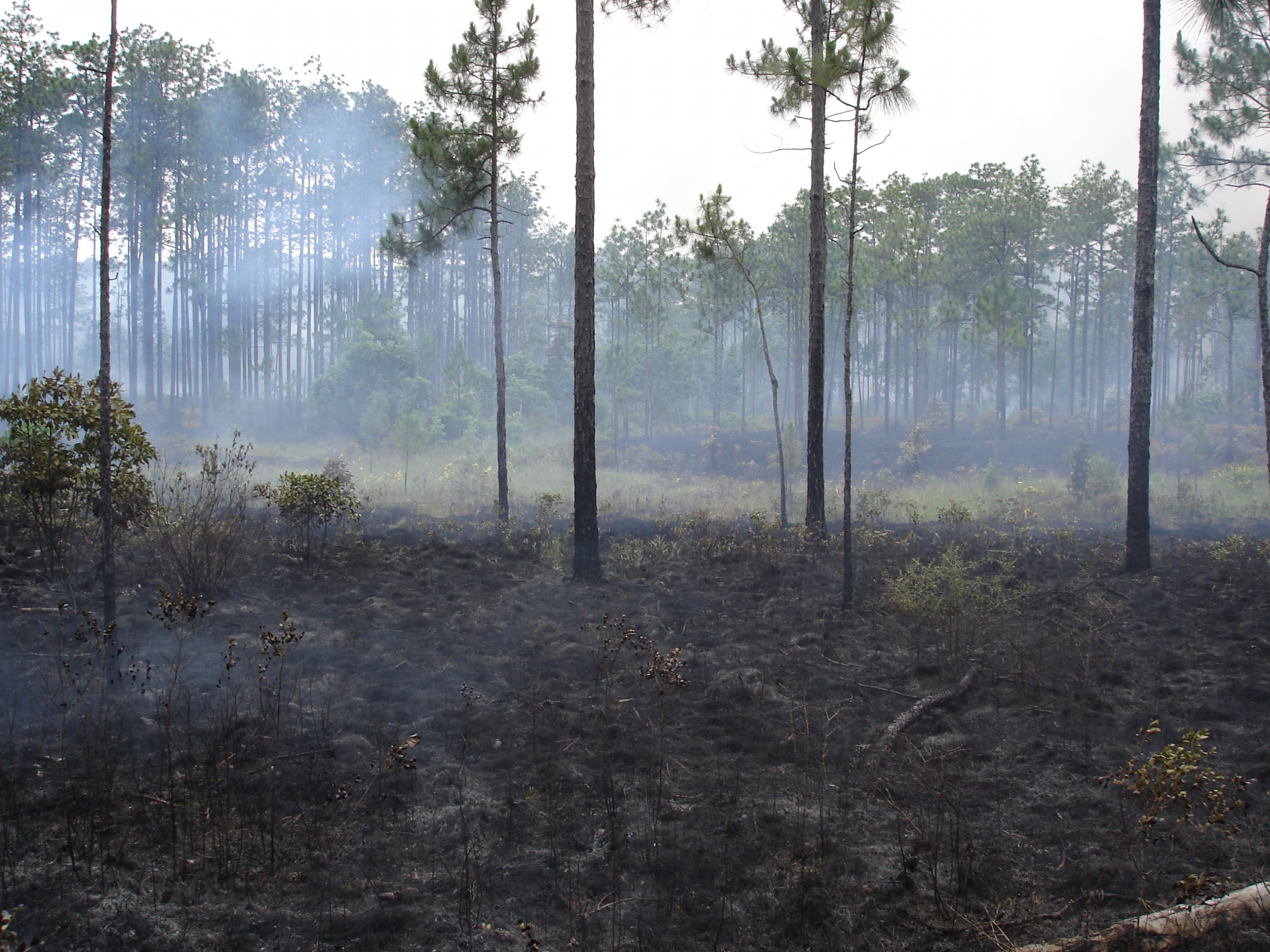
Aftermath of a prescribed fire, photo courtesy of the Jackson National Guard
These fires are managed by trained professionals, and should only ever be conducted by trained professionals. People who unlawfully start fires face harsh punishment.
What are satellites, and why do we use them to examine fire? Satellites are objects which orbit larger other objects in space. There are two types of satellites: natural, like our moon, which orbits the Earth, and artificial, which are created and launched into orbit by humans.
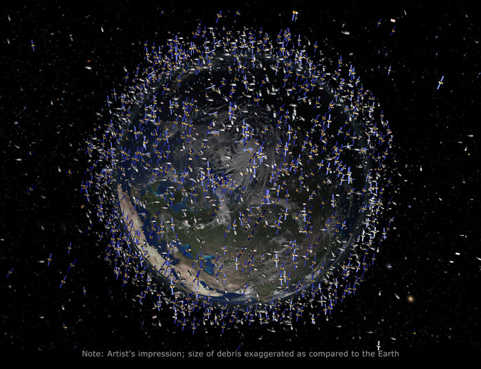
Image Credit: European Space Agency
Artificial satellites allow us to view the effects of fire from space, to observe patterns and take measurements that are not visible with the human eye, or are difficult to detect on the ground. Satellites see things that we cannot. There are currently over 1,000 active satellites and over 2,000 inactive artificial satellites orbiting Earth. These satellites range in size from as large as a school bus to about the size of a loaf of bread. To see a model of the satellites currently orbiting our planet, check out Stuff in Space.
Satellites are useful because the human eye actually can only see a small portion of the wavelengths of light that exist in the universe. All the wavelengths combined are called the Electromagnetic Spectrum (EM Spectrum). Humans can only see the portion that we call visible light. But the portions of the EM Spectrum which we cannot see give us deeper insight into the workings of our planet.
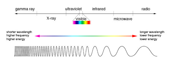
Image credit: NASA
When a satellite takes an image from space, it operates in a similar fashion to the human eye: it observes the reflected light across different sections of the Electromagnetic Spectrum. Unlike the human eye however, satellites can observe light outside of the visible spectrum, including infrared and ultraviolet light. For information more about the Electromagnetic Spectrum, visit: https://earthsky.org/space/what-is-the-electromagnetic-spectrum
In this lesson, you will be examining two types of satellite images: True Color Images, which show the earth as it is seen to the human eye, and False Color Infrared Images, which use wavelengths outside the range of human vision, such as infrared or ultraviolet radiation. False color images work by converting data collected by satellites into colors visible to the human eye, so that we can see them too. This lesson uses imagery collected from NASA’s Landsat 8 satellite, in 2014. Each pixel in a Landsat image represents an area 30 meters 30 meters on the ground, or 900 square meters. That means that anything smaller than that size isn’t detectable on the satellite image. However, this resolution still allows us to view changes over a large area. The Landsat program has provided imagery from all over the Earth since 1972. It’s been running for so long, that it’s ideal for examining how landscapes change over time.
Why use False-Color Infrared images? When we look at a True-Color satellite image of the prescribed burn in Blackwater River State Forest, we can see that a fire is present, but its location is hidden under the smoke.
But when we look at the same image while substituting Infrared light for red light and Near-Infrared (NIR) light for green light, we are able to see through the smoke and identify the fire’s exact location.
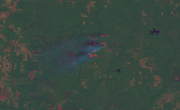
The fire is visible through the smoke, as bright red. Green areas are vegetated, the tan areas are urban centers and open fields, and the dark blue locations are water.
Another noticeable difference between the two images is that the False-Color Infrared image appears significantly greener. Healthy vegetation reflects more NIR than bare ground. This makes it easier to distinguish between land that is vegetated, such as forests, fields, and parks, and areas that are roads, bare earth, and population centers.
Fire is one manifestation of energy. Technically, energy is defined as “the ability to do work.” In the case of fire, that work is transforming landscapes. There are two main types of energy: kinetic (the energy of motion) and potential (stored energy). In addition to these two types, energy manifests itself in other forms such as thermal and chemical energy. To learn more about the different types of energy check out the US Energy Information Administration.
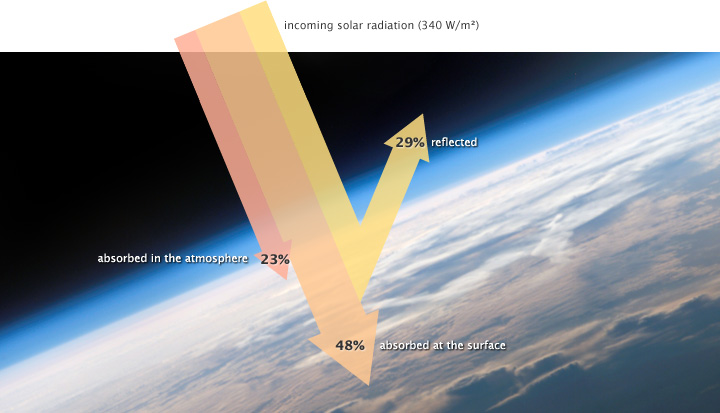
Image Credit: NASA Earth Observatory
The Law of Conservation of Energy states that energy cannot be created or destroyed, it only changes from one form to another. All the energy which fuels life on Earth originates with the sun; of all the sunlight which hits the earth, only 48% makes it to the surface. Trees and other plants absorb this incoming energy to fuel photosynthesis, producing molecules like glucose which store chemical energy.
During fire events, the chemical energy of plants is transferred to the surrounding air as light and thermal (heat) energy. While we can see fire with our eyes, the smoke produced by fire often obscures our vision. The thermal and infrared imagery capabilities possessed by some satellites are able to detect the location of fires through smoke cover that human eyes cannot see through.
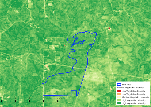
The image above was taken before the fire which shows vegetation intensity; all the vegetation within the outlined area represents chemical energy.
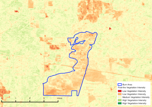
After the fire, the chemical energy of the vegetation within the outlined area was released as light and heat.
Satellite images can document active fires and their effects on the land from space. Use Google Earth Pro to view the satellite images of Blackwater River State Forest on 3 different dates following the fire, and document how the land has recovered.
Before this lesson, what was your opinion of forest fires? Has your opinion changed? If so, how?
What role does fire play in Longleaf pine ecosystems?
What are the benefits to conducting prescribed burns? What are the potential downsides?
Would you expect land that was burned by a wildfire to recover in the same amount of time as land affected by a prescribed burn? Why or why not?
What other environmental issues do you think Landsat satellite observations could aid? Can you think of issues for which it would not be helpful?
Based on the knowledge you have gained throughout this lesson, would you recommend the continued use of prescribed burns as a land management technique? Why or why not?
To complete this exercise, students will need:
For teachers, there is a guide for teachers and a teacher version of the Prescribed Fire KMZ file, in addition to the above resources.

 Shifting Sands on Petit Bois Island